 Despite the fact that the calendar has just flipped over to September, it is, as Adam says, still very much Summer. We are in the desert. It is Labor day weekend. It’s evening, around 5:30 or so, and it’s still at least 80 degrees. We have just dropped off the east side of Highway 12’s hogback; a narrow, windy, slip of road riding the steep-sided ridge between Calf Creek to the west and Boulder Creek to the east. Although I have traveled this stretch of road literally a hundred times, driving this tiny wedge suspended between dramatic drop-offs still leaves my adrenals stressed and my palms sweaty.
We are tromping across sandy hills covered still, thankfully, joyfully in Sand Verbena (a good name, we think, for a dog), Spiderwort (a flower, not some sort of horrible grow
 th), filmy white patches of Primrose, and Sunflowers. Soon, the sand spreads out across slick rock washes, stone looking as though the water that formed it were still running in rivulets across its surface. The ground is nearly white, occasionally stained gold, rust, or rose. The wash we are following heads down and down, connects with another wash, runs off to the side a little, meanders and then drops off into Boulder Creek.
We move slowly. I am still getting over a three week respiratory infection that had me in bed and then in bed and then in bed a little more. I haven’t carried a pack in a while and I feel laborious and clumsy. Adam skims on ahead of me, sauntering down the slick rock, his walking stick clicking occasionally against juniper roots and sandstone. Adam moves easily, he fairly glides down the steep descent we make to the creek. I have to walk looking at my feet so as not to tumble down the wash. I stop occasionally so that I can look around and remember where I am. I will never move as gracefully through the desert as Adam.

The country around us rises in domes, mesas and turrets, castle battlements made of whitish-gold sandstone. Thirty minutes later we get to the creek bottom, hot, a little irritable and happy for shady Cottonwood trees. This section of Boulder Creek is still relatively close t
 o town—more so than our usual adventure destinations—as evidenced by down-canyon-debris. We pass a big old oil drum, some graffiti etched into the sandstone declaring that “Emily is the Shit,” and a scrunched up green metal gate washed down by a flash flood. It’s obvious that a flash flood of some magnitude tore through here pretty recently. All of the ground cover, water loving willows and tamarisk lay flat, pointing haggardly down stream. It makes walking down canyon alternately a total pain-in-the-ass-thrash and an easy stroll since you can actually see where you are going rather than having to battle through thickets of willows, looking for a trail. Flood debris—bunches of leaves and dirt and bird feathers—rides high in the tops of any tamarisk still standing. A waterline, like a grimy bathtub ring runs close to the canyon walls over even the highest banks. Finding high ground in this flood would have been nearly impossible.
 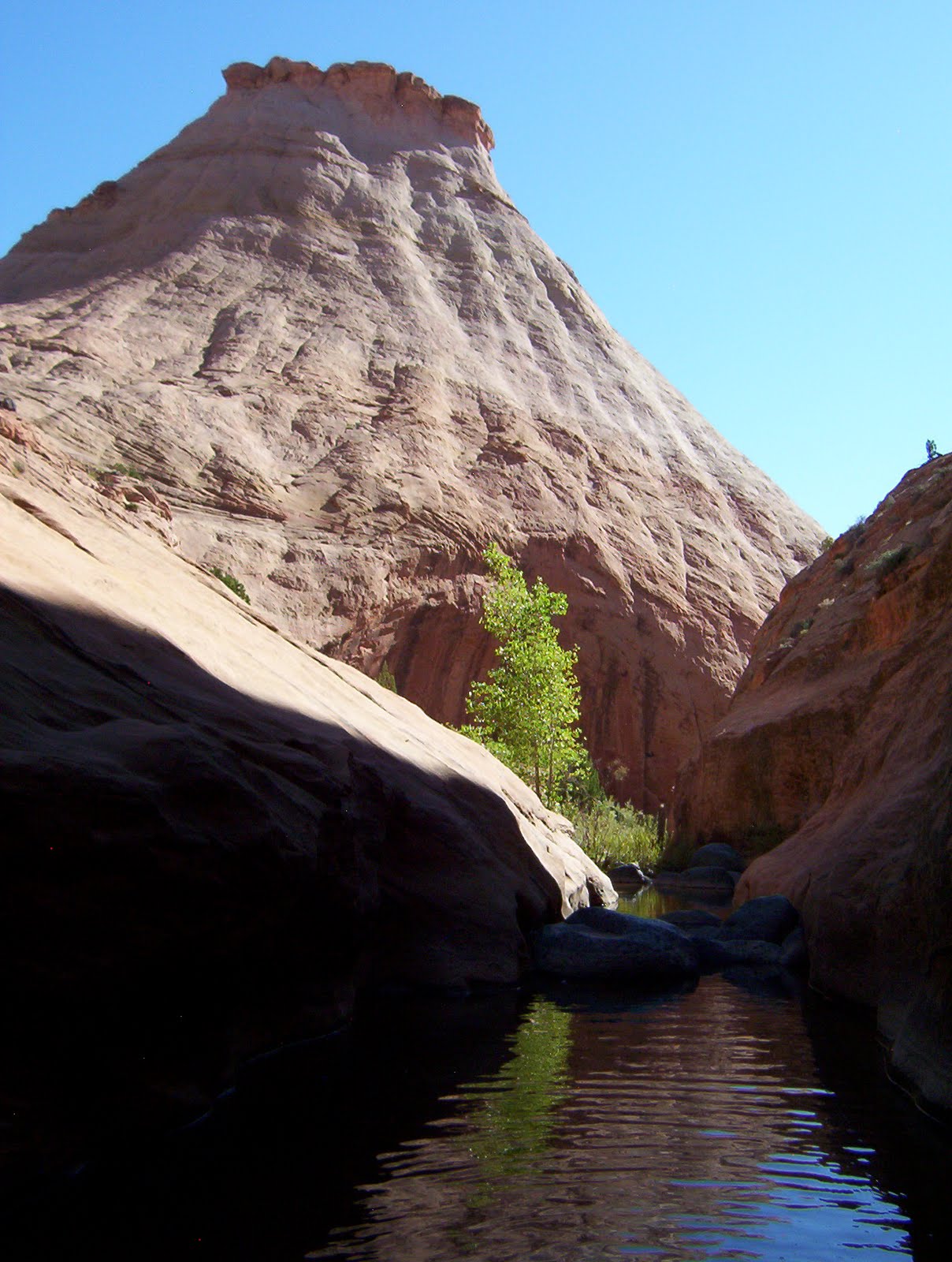 Even as we thrash, Adam and I look at each other every few minutes with wide grins. It’s a thrash and a pain but we are in the desert! It’s been nearly two months since our last trip and the last few weeks have seen us stopping every so often to stare out the window and sigh, longing vocally for a wet canyon and some Cottonwood trees. And here we finally are. As I thrash and trip and stroll, I bring the world down to sounds and smell.
There is very little sound. The pitch of the water riffling down creek shifts slightly depending on whether it’s passing over pebbles, sand, slime, or smooth rock. I can’t hear any birds. I don’t even hear bugs. The air smells awesome. Clean and green and a little mulchy from the flood dregs and that smell particular to rock eroding away under the force of water whether rain or sprinklers or river.
Because we are still relatively high in elevation, we pass the occasional towering Ponderosa; some, burnt out carcasses, lightning struck. Signs of people become more faint. We hike nearly three miles and even though we are headed further down stream tomorrow, decide to camp at what is an exit trail, forming a loop hike that could take you back to the trail head, up on the hogback of Highway 12. This trail too, follows a wash. We scamper up a short wall to a little ridge overlooking the smooth sandy wash bottom. The sand is spotless, not even a bird track. The sky is clear with no forecasted rain. We plop our stuff down right in the middle of the sand and lie out.
 Our packs are ridiculously heavy for a three—not even full—day trip. This is largely due to the mass quantity of food we brought with us. We are not scrimpers when it comes to food, Adam and I. Adam is a beanpole and we both have blood sugar issues so we need an almost constant stream of calories when hiking. Nuts and other usual backpacking fare won’t cut it however so our food bags are filled with turkey, hard boiled eggs, fresh cucumber from the farmers market, bell pepper...tonight we hover over our cook pot chopping cilantro and green onion to throw into the Pad Thai we are making. A few years ago after I took my whole (almost) family backpacking for the first time, my dad asked my 13 and 15 year old brothers what they had liked best about the trip. They uniformly agreed that the food, not the soaring red walls of Coyote Gulch, not the impressively sized Steven’s Arch, not the pictographs and Anasazi ruins, had made their trip. Nope, it was the miso-ginger-chicken soup I had made the first night out. I guess I’m flattered, but almost anything tastes good when you’re backpacking.
When we lie down to sleep, the crickets are really getting going, pulsing rhythmically into the night. Just above our heads are a series of potholes with slightly stagnant murk crusting over the top. After a few games of Mille Bourne, we turn our headlamps off to flee the gnats and mosquitoes. A few minutes later, without the mesmeric drawing power of the light, the bugs recede and we settle in to a peacefully star-lit night.

The next day we proceed down canyon, stopping at the first real show of entrenched narrows for second breakfast. The canyon is filled with willows and rose bushes t hat tear at our legs and drive us to criss-cross the stream again and again looking for a clear path. Then, hurray! a smooth rocky sidewalk rises up out of the creek for a stretch, making for delightfully cruisey walking. Just around the corner from where Deer Creek intersects Boulder, we find our exit point and settle in for a lazy and utterly quiet afternoon.
I read. Adam naps and takes short walks up and down the creek, closely examining a patch of thick green moss, some bug larvae, fish hiding beneath the stream banks. I find a deep enough section of creek just below our hangout to take a dip. I watch for birds and look around at the gold walls. I eat a little and wander around barefoot. Adam eats a little and sleeps some more. The afternoon passes. We don’t see another person all day. Just before sundown we hike out, back up onto the golden-white citadels and boulder-strewn mesas above. At the base of the steep pass we need to mount the next day we make camp and look out at the view. Across the creek stretches a slick rock play ground called the Brigham Tea Bench. Between the domes and scalloped tops of the bench lay little green valleys filled with gold flowers and pinion pine. We sit, lean back on our packs and watch the day slowly disappear.
 hat tear at our legs and drive us to criss-cross the stream again and again looking for a clear path. Then, hurray! a smooth rocky sidewalk rises up out of the creek for a stretch, making for delightfully cruisey walking. Just around the corner from where Deer Creek intersects Boulder, we find our exit point and settle in for a lazy and utterly quiet afternoon.
I read. Adam naps and takes short walks up and down the creek, closely examining a patch of thick green moss, some bug larvae, fish hiding beneath the stream banks. I find a deep enough section of creek just below our hangout to take a dip. I watch for birds and look around at the gold walls. I eat a little and wander around barefoot. Adam eats a little and sleeps some more. The afternoon passes. We don’t see another person all day. Just before sundown we hike out, back up onto the golden-white citadels and boulder-strewn mesas above. At the base of the steep pass we need to mount the next day we make camp and look out at the view. Across the creek stretches a slick rock play ground called the Brigham Tea Bench. Between the domes and scalloped tops of the bench lay little green valleys filled with gold flowers and pinion pine. We sit, lean back on our packs and watch the day slowly disappear.

The next morning we are hiking by 6, trying to beat the heat of the sun and get back to the truck by 10. The walk is a constant delight as this is country I have never seen except from the distance of the road and the isolation of my car. Flowers decorate our path, surprising us at every turn. Once back at the truck, we decide to make our way home as slowly as possible, relishing our vacation to the last minute and take the long way to our next destination: The Antimony Mercantile. Stopping briefly at the visitor’s center in Escalante—which is strangely deserted of tourists on what should otherwise be a rowdy weekend—we take off up Main Canyon and over Boulder Mountain. We drive slowly, smelling the Ponderosa scented air and looking at the remains of past forest fires, musing about our time working on the mountain for the Forest Service. As we climb, we pass the corner in the road where I cut through my first really huge tree with an ax. We pass several trail heads we both meant to explore during our seasons on the trail crew. We slow down at Adam’s favorite look-out spot and take in the view: the Straight Cliffs from head to the toe, the entire Circle Cliffs uplift, the Henries, and Mancos Mesa all the way over by Lake Powell.
The Dixie Forest, of which Boulder Mountain is part, is not a grand or dramatic range. But it is gently lovely, littered with any number of meadows—filled now with flowers—and hundreds of little lakes and ponds. Sweet relief when the desert proves too steamy. Coming up over the crest, we run into a cavalcade of ATVs, headed off on a hunting trip. The more volcanic parts of the mountain blend on this side with dramatically red outcroppings that reach full expression further south in Bryce Canyon. Every time we stop to look at a good crumbly hoodoo, peeking up from an otherwise green hillside, a truck full of hunters stops to look, hoping we’ve spotted a buck.
The Main Canyon road we are taking is also sometimes called the Widtsoe road, even though Widtsoe is barely a destination. With 1,100 residents in the late 20’s, the town was once considered as a location for the county seat. Mostly a ghost town now, the township hosts a few mobile homes and one original log cabin. The last time I visited Antimony Merc (17 miles north), there was a man at the bar who told me the classic pioneer tale of growing up in that cabin with his 13 brothers and sisters. He had to be at least 90. We pass Widtsoe as we leave the mountains, entering John’s Valley. Both the names “John” and “Widtsoe” come from John Widtsoe, the president of the University of Utah in 1917, whose expertise in dry farming helped farmers in the area eek out an existence for nearly two decades before finally moving south to the San Juan.
Intersecting Highway 22, we head north and soon drop into Black Canyon, an intimate little gorge with a marshy creek running along the bottom. At times the walls of the canyon loom up grey and bold right next to your car, then spread out eroding into steep rubbely hills cresting hundreds of feet above. The land above is flat as flat. The canyon bottom feels like a hidden world.
 In Black Canyon, 12 miles north of Widstoe is another ghost town; Osiris. Well, not really a ghost town as there was only ever one house there—still there and hidden up in the trees—and the remains of an old creamery, perched on the edge of the creek. Every time I pass the creamery, I badly want to explore it. The creamery was built in the twenties, turned into a granary, and abandoned in the 30’s due to drought. The main building is tall and narrow and not at all forbidding considering its isolated location and age. The windows are open and free from glass, making it all the more tempting to crawl right over the sorry-little-fence surrounding the premises, mount the rickety stairs, taking them right to the top.
By the time we reach Antimony we are starving. Antimony is a sort of story book town. The main street is tree lined, enormous old cottonwoods and poplars. Alfalfa fields roll off the road and down into a valley cut through by a number of creeks. Clearly happy cows loll and laze. The few—nearly all historic—houses in town are set back from the road, surrounded by more trees. There is, unfortunately, an abomination of a dude ranch with a huge, plastic, rearing white stallion on the roof of the guest house. And then there is the Antimony Mercantile.
 The Antimony Mercantile is a combination grocery store, bait &tackle shop, diner, gas station (with old fashioned pumps), R.V. park and one of my favorite places on earth. It’s not enough that they make their own pie, fresh every day and that their burgers are the definition of slutty goodness, it is the whole package that I love. Inside, the ceiling is low and the shop is jam packed full of stuff. All kinds of stuff. The grill has a bar running long side it and around the corner is the little indoor eating area. The walls surrounding the tables are full, I mean every inch full of pictures of locals with their freshly caught fish, freshly shot elk, slung over the back of their ATVs. There are a few little cubby shelves stuffed with cheap, used paperbacks that you can take, if you leave one in return. There are a few chotchkys, mostly fishing related. Then there is the porch, the best place to sit.
T
 he back porch is littered with picnic tables and metal tables surrounded by mismatched chairs. The roof is made from rough hewn logs and decked with ceiling fans, indoor faux-wood ceiling fans, looking like they’ve been taken from some old dear’s bedroom. There are a few plastic cacti hanging on the wooden back wall of the porch and two outdoor restrooms with “Doe” and “Buck” written on the doors. Next to the porch is a little horse shoe lot, where two guys are playing horse shoes. There is a Jeep parked dangerously close to the end of the lot and each time the men turn to throw that direction, I cringe in disastrous anticipation. The whole back R.V lot is surrounded by tall cottonwoods so that the porch is always shady and cool, even when it’s broiling out.
All summer old folks set up their RV’s, go fishin’ all morning, then spend the afternoon chatting on the porch, drinking coffee and coke from the bottle, and smoking cigarettes. These people now live in Florida but come back here to be with their grandkids and ride ATVs around the mountain. They all know each other. Have for decades. We sit at an old picnic table. Next to us are two couples in their seventies. The men wear impossibly baggy Lee jeans held up by rainbow striped suspenders. The women have on layers of fusia lipstick and hairsprayed hair. One has a little nondescript white dog on her lap which she talks to in baby talk, calling it “baby” and referring to her self as “momma” as she feeds it little bits of burger. The other woman moans pornographically over her burger, exclaiming “oh my!” and “this is soooo good!” through mouthfuls of food. The family to the other side, the one playing hose shoes, jokes and laughs and compares the effectiveness of ATVs as hunting vehicles, “The problem with the new Polaris is that it doesn’t have any room! You can put an extra gas can on the back, but where you supposed to put your deer once you kill it?!” None of these people are in a hurry. The wind rustles the trees every once in a while. The whole scene is slow and soothing.
When our qu
 ick moving, fast talking, locals chatting, cowboyboot wearing waitress brings our food, Adam and I don’t even talk to each other as we eat, we’re so hungry. I of course, order the Antimony Burger. I always order the Antimony Burger but have not, until today, ever been able to finish it. It is a ½ a pound of meat, gooood tasty meat not that soy bean crap, topped with lettuce, tomato, onion, melted cheddar cheese, mushrooms (from the can, but who cares) sautéed with more onions and bacon. Thick, peppery wonderful bacon. I don’t know what they do, I think I can taste garlic salt, but this
  burger is amazing. I can’t stop smiling as I eat. I am sold. They, as far as burgers go, win.
We move on to cherry pie with ice cream and homemade cinnamon rolls, drizzled with frosting. We smelled them when we first came in, an hour ago now, and get the last one. The pie crust is home made, flaky and thin. The cherries are from a can. It’s still good. When we are finished eating, we linger, stuffed and happy. The breeze moves around us. We look around and listen. We grin at each other.

A little bit of useful info…
Region: South Central, Utah
Contact Info:
(435) 624-3253 70 N Highway 22, Antimony, UT 84712
Rating (out of 5) ☼☼☼☼☼:
Burger ☼☼☼☼☼ Fries ☼☼ Shake N/A
You may want to visit the Antimony Mercantile if you are…
* Fishing at Otter Creek and/or Otter Creek Reservoir
* Camping up Antimony Creek
* Riding ATVs around on Boulder Mountain or up Antimony Creek
* Fishing or hunting on Boulder Mountain
* Driving an RV around the South West
* Driving an RV around to all the National Parks
* Climbing at “the Jungle” on the Aquarius Plateau (Boulder Mountain)
* Driving home from Escalante and environs
* Visiting Bryce Canyon National Park
* Touring Utah’s ghost towns—see: The Historical Guide to Utah Ghost Towns by Stephen Carr. * You can find this at Sam Wellers and Ken Sanders in SLC
* Hiking or horse back riding the Great Western Trail
* Eating your way home from somewhere great!
Region: South Central, Utah
Contact Info:
(435) 624-3253 70 N Highway 22, Antimony, UT 84712
Rating (out of 5) ☼☼☼☼☼:
Burger ☼☼☼☼☼ Fries ☼☼ Shake N/A
You may want to visit the Antimony Mercantile if you are…
* Fishing at Otter Creek and/or Otter Creek Reservoir
* Camping up Antimony Creek
* Riding ATVs around on Boulder Mountain or up Antimony Creek
* Fishing or hunting on Boulder Mountain
* Driving an RV around the South West
* Driving an RV around to all the National Parks
* Climbing at “the Jungle” on the Aquarius Plateau (Boulder Mountain)
* Driving home from Escalante and environs
* Visiting Bryce Canyon National Park
* Touring Utah’s ghost towns—see: The Historical Guide to Utah Ghost Towns by Stephen Carr. * You can find this at Sam Wellers and Ken Sanders in SLC
* Hiking or horse back riding the Great Western Trail
* Eating your way home from somewhere great!


