
My cat is not stupid. So when she sees sleeping mats piled next to the door and sleeping bags laying limply over the back of the futon, she knows she is about to be abandoned. In the past when we began throwing food together in preparation for a camping trip, she would sniff around curiously, occasionally jumping in and out of the blue plastic storage tubs we use for dry good, batting at the small silver packets of Gatorade powder. Now she gets one whiff of dehydrated beans and curls up on the radiator with her back to us. Which is where she sits now. The car is all packed and we’ve doled out her extra food and water. We pause at the door to meow a farewell; she does not acknowledge us.

The reason it has taken Adam and I so long to get the hell out of here is, as far as I can see, some kind of weather curse. It began Thanksgiving weekend when, after Adam had already taken extra time off for a trip, temperatures dropped around the state to 16 degrees during the day and below zero at night. St George, Bluff, Escalante, it didn’t matter. It was freaking cold. The pattern continued for every trip—including what was supposed to be his birthday getaway—until now, the first weekend in March, spring in site. Which is why, despite the fact that I am sick and uselessly blowing my nose every ten minutes, we are leaving. Outahere. Vamoose. The backcountry of Capital Reef, highs in the 50’s and lows around 20? Seems edenic.

The asymmetrically slumping sandstone and neverending arches of Upper Muley Twist must wait though, as first we have a side stop to make. Since I started writing for a food column once a month, reviewing little restaurants in the middle of nowhere, pleasure must be mixed with a little business. Today business takes me to Mom’s café and the middle of nowhere for now is Salina, UT.
Doing a little research, I read that Salina wasn’t always the middle of nowhere, but it sure looks like it now. The median income for men here is $30,000 and $16,000 for women. Who knows what they do. Supposedly the current home of over 2, 000 people—very few of which I can see anywhere—Salina has boomed and busted several times since it’s foundation in l864. Or at least that’s when the first attempt at foundation happened. Brigham Young sent a group of Mormons down to settle the place in 1864 but the Native American tribes, who as it happened had already “founded” the valley, would have none of it and for the first decade the presence of white people led to more wars than crops and churches. The 1870’s saw the creation of a militia and a fort and bygod those settlers showed the natives what was what, discovering huge salt and coal deposits as they went, and were on their way to building a more white and delightsome country. Then, after all that excitement, nothing happened for nearly a hundred years.
During WWII, however Salina became the location of a POW camp for Germans and the site of the “15 second massacre.” Apparently being in the middle of nowhere was too much for at least one of our boys, who perhaps had thought war time for him would mean French women and wine and instead found himself womanless, wineless and in Mormon country to boot (where there wasn’t even chance of wine), whereupon he climbed a guard tower and began shooting at random. After that and one more brief flurry of activity when the CCC came to town and built a new town hall and septic system, the city went back to its normal routine. Which is to say; nothing.
In the middle of all the remains of little bursts of somethings and nothings, sits Salina’s current claim to fame; Mom’s Café. I first heard about Mom’s from my friend Noreen. After working in London during the blitz, Noreen sought peace and quiet and the hot nurse she had fallen in love with during the war, in Florida. Florida became Utah in 1974 and Utah meant adventure. At the juicy age of 50, Noreen took up backpacking. On one of her many trips to Grand Gulch and Steven’s Canyon—where she would hike in with cast iron pans, sides of bacon and eggs, and her new hot girlfriend—Noreen stopped at Mom’s. She brought up the restaurant jokingly once when we were at dinner. When I asked her how it was, she shuddered and said no more. Considering we were eating scallops with lavender and drinking Cloudy Bay at the time, I took her declaration of the food’s value with a grain of salt. I had seen the sign for the place along highway 50. Faded and peeling, I assumed the café was long gone. So I was completely delighted when Adam assured me it was alive and well and that he had been there with his mom just a few years earlier. After a scouting trip to assure myself of its existence, I bided my time and planned for a visit. Today is the day.
We coast into town and the streets look dead. Most of the buildings we see are vacant or closed. I start to make note of the “Gator’s Drive-In” for future food hunting visits, then notice that no gator’s have served burgers there for a long time. One shop is open though, the Saddlery, which is even marked on our 7.5 minute map and featured prominently on Google Earth; it’s that important…or perhaps just singular in this wasteland. The two block section of town evidencing the remains of “old Salina,” home to “Mom’s,” is equally empty; the beauty shop still loaded with the kind of hair dryers that encompass your head in a heated plastic cavern while you sit reading magazines, sits across the street from Mom’s, graying with age.
Mom’s is also graying with age. The ceiling is low and the walls are dark wood—well, wood-looking—making the room feel a bit like a cave; the cave where time stood still. On one hand, I like that rather than trying to convey some nostalgic sense of the past by decorating the café like a 50’s diner, Mom’s still is a 50’s diner: big metal soda fountain and shake maker behind the counter, tall once-orange topped metal stools, original naugahyde green booths, off-green paint matching the waitresses’ off-green smockish dresses with clashing seafoam trim. But the result of this packratish impulse is unfortunately dingy and a little sad. The shake maker no longer works.

While we wait to be served, we read from the “humorous” little flip-books adorning every table. Books with titles like, “Tall tales for Fisherman” and “Understanding Women,” with a caricature of a huge bride and an at-his-wits-end looking skinny little groom on the cover. We open one book up at random and flip to the section on jokes about “animal lovers.” The narrator makes some quip about how he knows a lot of people who are simply incapable of having a sense of humor and how animal lovers unfortunately fall into this category…huh? At this point, out waitress, Kathy, shows up.
The menu at Mom’s features classic diner fare: homemade soups and pie along with dishes like chicken fried steak, steak and eggs, and a Friday-night spaghetti special. I, of course, order a burger and fries (I’m on a mission after all) and pie. Adam orders the chicken fried steak which comes with side of vegetables, salad, what passes for a scone in Utah, and mashed potatoes. Kathy tells us that we can get our own salads or she can make them. Confused for a minute, we look around the corner and find a minuscule salad bar dividing the front room from the back. I think the last time I saw a salad bar was in Iowa at the Ponderosa Steak House, located in the parking lot of K-Mart, in 1992. Because it’s a novelty salad-bar salad, I enjoy it. But the novelty is pretty thin. Everything except for the shredded iceberg comes from a can: canned beats, canned olives, canned waterchestnuts. We are, after all, in meat and potatoes country where “salad” usually means gello salad, so I’m not really surprised.
After eating our salads, we wait. While we wait, I people watch. The room in the back has several families in it; grandpa with his cowboy hat on his knee, kids in matching t-shirts. A table of guys sits next to us. Eavesdropping, I learn that they come here every week together, fathers, brothers, sons and friends from work. They live in several of the surrounding towns—Richfield, Gunnison, etc.— and have been coming here for years. I peruse the community board behind me; Sue is having a birthday party and everyone is invited. Several games of twenty-questions later, our food arrives.

My burger is…not great. The patty is good; not over done and it tastes of charcoal, no fried. But the bun is squashed and average. They give me a pickle spear instead of sliced pickles. Boo. The lettuce is limp and iceberg. But the tomato is the worst. I know I have a cold and it’s not tomato season, but when a tomato is that mushy and mealy and…grey; throw it away!!! And the fries, which I have read rave reviews about on Urbanspoon.com, are limp and cold. Limp! And cold! Throw them in some more oil for chrisake, more oil isn’t going to hurt anyone here! Travesty.
But we have pie to look forward to, right? Mom’s is famous for their homemade pies. Indeed, the side of the building facing highway 89 is painted with super tall letters celebrating the fact. Today, we have a choice of apple or sourcream blueberry. I have never heard of sourcream blueberry pie so I am in. The mound of whipped topping obfuscating the pie, I have come to expect. But the blue colored, syrup topped, pile of lard underneath, I am not at all prepared for. We ask for a to-go box and smile politely as we leave.
Luckily, this is only the beginning of our adventure, and really, I’m not that disappointed. I wanted to go there, and it was a unique experience, which is exactly what I want out of one of these small town visits, so…were good. As we continue east on state route 24, I am a clapping kid once more. The desert awaits.

Later in Boulder…
Just beyond a sign reading, “Caution: road may be impassible when wet etc. etc…” dating from before the road was paved, towering slick rock domes that I have always wanted to wander around rise and fall. We get out of the car and start up a small wash, snow sticking to northfacing little hummocks and hills, pinions and ponderosas littering the drainage. Just as we turn to walk between two sandstone mounds, a German Sheppard, hind quarters badly wrapped in a bloody old t-shirt, comes trotting up to us and proudly drops a deer’s hoof at our feet. From the brush, we hear someone call out, “be careful!”. At first, I am not sure whether they mean be careful of the dog and I look around trying to find the source of the voice.
Two characters come walking out from behind a tree, looking like they’ve been wandering in the wilderness for days. They haven’t, I learn, they live across the street and apparently always look that way. They are a man and a woman, wearing matching Carhartt coveralls and smoking. The woman has a sort of holster around her waist where she carries a buoy knife the length of my arm. The man, no older than 45, has lost all his teeth and the woman has weathered looking skin and wild redgold hair. “Be careful” she repeats, “there’s a cougar out. Got our dog and our pup. We’ve been out looking for the little one. Found this guy. Looks like she got him so we wrapped him up.” It’s only now that I notice the t-shirt hung loosely around the Sheppard is lamely covering the fact that his side is torn open. I look away. “He found that” she gestures at the hoof, “so we let him have it.” The man smiles toothlessly. “The dogs had been whining about something at night for a few days, so we figured there was a cat out,” he says. By cat, he means mountain lion. “So keep a look out.” Adam assures them we will let them know if we see any trace of their pup. I’m hoping me don’t; if there is anything left of the dog, it won’t be much.
Adam and I wander further up the drainage, cross a brush fence, and then begin scampering straight up the slickrock. I make my way up the incline, looking for little edges in the corssbedded layers of sand to follow up the dome’s sides. Adam follows a slightly wider, golden shelf to a small pour-off which he clambers up. The apex of the mound is broken, creating several peaked tops. Reaching one, I can see over the Ponderosas, across the Burr Trail, to the valley on the other side. There are one or two small houses backed by another slickrock mound, rising easily 50 feet above the tallest roof. The houses have springs and ponds, making their yards green and marshy. Man, I want to live in Boulder. Looking east, I can see pretty far along the Burr Trail towards the Circle Cliffs; mesas and mesas of red and white. The sun comes out from behind a cloud and a cold breeze starts up, biting my face. The sky, which has been sort of hazy all day, succumbs to the wind and clears, so blue it’s practically shouting. I breathe in and feel I am actually here, feet shaping themselves to the sandstone below me, body conforming to the curve of stone so that I can maintain my balance as I make my way around the dome’s roof with measured steps.
After 20 minutes or so, Adam and I nod at eachother and begin to find our way down, leaning our bodies against the sides of the dome as we walk slantwise to its base.
Upper Muley Twist…
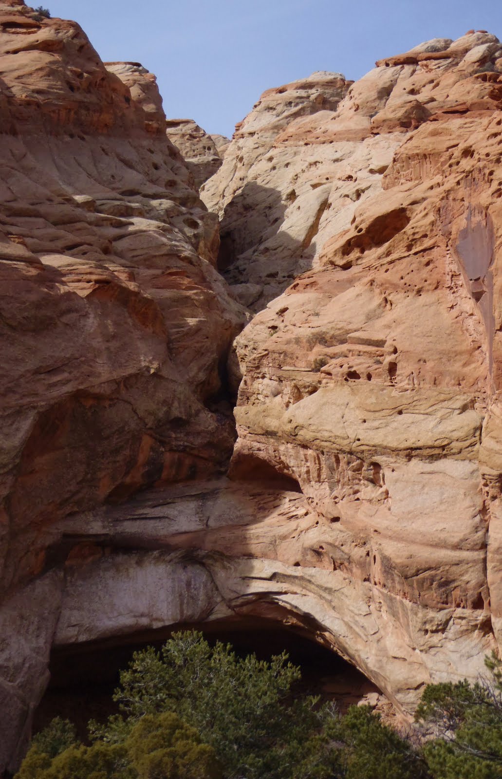
We are creeping along the bottom of a wash in Adam’s truck Snorry; creeping because the wash is choked with boulders and flood-wrecked tamarisk. The wash cuts behind the Waterpocket Fold, a monocline tilting gently upward through millions of years of silt and sand deposits. At times, the walls of the wash narrow and rise above us, smooth sandstone pocked with concave little holes like bubbles that have burst. We pass below a massive arch, high up to our right on the reef formation. On our left, the rock wall runs in fits and starts, blobs of stone dripped down in 200 foot scallops and ridges. We pass below a set of intersecting arches. Sinuous chutes cascade from the top of the rock formation. Water running its course through these chutes softens the sandstone, leaving it vulnerable to the wind. After millions of years of this intense exposure the rock opens, forming these arches. Adam wanted to come here for his birthday trip explicitly to explore slots like these, but there are quite a few and he’s not sure how much time he will actually have for exploration. There’s no beta on these curvilinear chutes, as far as we know no one has descended them, so who knows how involved they will be.
After 4 miles of cutchunking over boulders and winding between hunks of fallen wall, we reach the Strike Valley Overlook Trail Head. Technically, we shouldn’t camp right at the trail head, but it’s early days and I doubt the ranger’s out. In a lame attempt at tempering our transgression, we set up our tent in the “parking lot,” a round of dust with relatively fewer boulders than the rest of the wash. An abbreviated deep red wall, about 40 feet tall, reaches up behind us. A single juniper crags out from the cliff, jutting hauntingly out into space. Behind that, the gold walls of the reef formation split and loom hundreds of feet up.
The last time Adam and I were in Upper Muley Twist was October 7th, 2006. I was in school and had come down for a break to go backpacking and see Adam who was living in Escalante. We had tossed around the idea of going into Coyote Gulch, when it started to rain. Then we thought about heading into the Gulch; a wide canyon, approachable by paved road, less chance of getting flooded out. And then it rained harder. And so we didn’t really go anywhere. On October 6th, we holed up in our tent along a spur road leading nowhere from the Burr Trail. We cooked under the vestibule of our tent as it poured and read John McPhee until water was running through our tent. Because there was really nothing to do about that, we just scooched to one end of the tent until the water subsided later that day. When the deluge let up, we wandered out across the sand dunes to a few red domes of slickrock. Climbing to the top, we found potholes brimming with clear rain water. Lying belly down, we dipped our faces, drinking our fill and then some. We barely made a dent in all that water.
We found out later that that storm had caused Hundred Year floods all over the Escalante area. Cozy in our tent, we had no idea that an area usually receiving 8 inches of precipitation on a good year, was receiving 4 inches in 6 hours. While hikers were stranded down Hole-In-the-Rock Road for three days, while roads were washed into oblivion all over the area, we drove to Upper Mulley Twist where the wash cutting the reef in two flooded torrentially. We listened to it flood all night, accented by the sounds of rock falls and coyotes howling, and in the morning it was gone.
We set up our tent in the receding sunlight and listen to…nothing. There is no water in the wash now. Very little life around. Too early in the season for bugs. The loudest sound is our own breathing and the crinkling of nylon as the rain fly flips in the breeze.
An invalid holiday…
The next morning, Adam loads up his backpack with helmet, harness, webbing, o-rings, rapedes, 400 hundred feet of rope, a sandwich and an emergency whistle. “If I’m not back by the time the light hits that rock,” he gestures across canyon from our camp, “come looking for me.” He leaves me his spotting scope so I can watch his descent from the opposite side of the wash if I get bored…or if he gets stuck somewhere. I kiss him, he tells me he’ll see me later. The wind whips in my ears, dragging wispy vales of clouds across the sky. I turn towards the truck for a second where I’ve been cooking breakfast. When I turn back, Adam is already 100 yards down the wash, his boots kicking up sand and gravel as he walks.


These cliffs are made up of mudstone, sediment laid down by a prehistoric river. Millions of years of fish shit. It is interesting to me that a massive pile of mud should put up such resistance to change, should sheer off so angularly rather than simply melting away like the Wicked Witch at the first sign of water. It’s also unfathomable to me that there should be ranches and prized buffalo hidden away in the ashen labyrinth between myself and the Henry Mountains, which surmount the Mesa to the east. But there are. In the 40’s, 18 buffalo were released in the Henry Mountains where they continue to thrive, wandering down onto Swapp and Tarantula Mesas in winter. To the north, a well graded road veers off its central north/south trajectory to wind back behind a limy wall and right up to the outbuildings of a ranch that has been active since the 1800’s: madness? Obsessive drive for aloneness? A passion for collecting rain water (all 8 inches) in rain barrels only to see how many months you and your hundred head of cattle can go before you are sucking on rocks? As beautiful as I find this subtly colored landscape, it is exactly because it seems beyond use that I love it.
The greatest-hits-drive-home…
Because my thirst for deep red is barely slaked, we drive home the next morning via the central gorge of Capital Reef. There, the Moenkopi formation is layered between the Morrison and Wingate like thick chocolate fudge in a 12 layer dark chocolate cake. In winter, when deep ground seems inaccessible, I sometimes feel starved for richness like this. Today is not the first time I have felt on the verge of pulling over to feast; face slathered, fist over fist of loamy, musky, dark scented earth.

We follow the swollen Fremont, past my favorite swimming hole, out of the canyon, and west towards Torrey. Stop to play in Cohab Canyon—named for the mormons who hid there from federal officers hunting polygamists just as Utah was becoming a state—and then turn away from the red, the river, and head up onto Thousand Lakes Mountain. Snow blows over the road, forming drifts several feet tall, attempting to pull the truck into its banks. Otherwise the range is gentle, easily sloping and filled with springs and creeks and reservoirs. Moment by moment we leave the southern desert behind, leaving me aching for more.

Authors note:
The reason for the loooong interval between my last post and this one is a reason for celebration! See the Outdoor Utah Adventure Journal for my published work!
http://www.outdoorutah.com/adventurejournal/
A bit of useful info…
Region:
South Central Utah
Contact Info:
10 East Main StreetRating out of ☼☼☼☼☼:
Salina, UT 84654-1332
(435) 529-3921
Burger: ☼.5 Fries: big fat zero
Other:
Chicken fries steak and gravy: ☼☼☼☼ Mashed Potatoes: ☼☼☼☼☼
You may want to visit Mom’s (where you will not order fries or pie) if you are…
* Visiting the cheese curd factory in Loa
* Hunting in or riding around on ATV’s or horses in the Tushars
* Tubing down the Sevier River near Big Rock Candy Mountain
* Heading to Colorado along I-70 to rock climb or hop on a river
* Camping/climbing in Buckhorn Wash
* Kayaking the Chute in the San Rafael Swell
* Heading to or from Capitol Reef!